
San Francisco
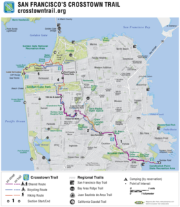
SF Crosstown Trail Map
My San Francisco adventure was is marvelous! Before I share details, though, indulge me as I give thanks.
First, off to play for four days, what with a needy four-legger and a crazy busy law / fiduciary practice, happens only because LB minds the store, and Max. As I age, I recognize the need for breaks and nary a one gets a challenge from my best friend, girlfriend, and law and business partner. Thank you, sweetie pie.
Second, Leigh and I go nowhere if we didn’t have a great young attorney, Matthew Scarber, to step up. Thank you Matt and, too, the staff we love – Kathleen Dugan, Carla Flores, Katie Petrick, and Connor Tully – who attend to us, whether we’re showing up or not. Thank you, all of you.
The Trail
San Francisco Crosstown Trail. It’s a less than a year old trail which starts at Candlestick Point State Recreation Area and ends at Lands End Lookout. Southeast to Northwest, and you want to go in that direction. Explanation later.
I read about the trail here, last November. I made plans for January; unfortunately, life happened. New date? February 22. And a one-day thing, which the Golden Gate National Parks Conservancy says, is “definitely grueling, but rewarding if you can pull it off.”
Why the Trail? Why San Francisco?
Three reasons, mostly. First, my parents lived here when I arrived. Nevertheless, I’d never really seen San Francisco, but for many visits which encompassed not much more than the Financial District, Union Square and, all right, I did wander into the Marina and spend a bit of time in Sea Cliff, once.
Second, an aunt awaits me in Napa. I’ve been a less than good nephew when it comes to showing up.
Finally, let’s get real: with four pneumonia diagnoses in my past and what was probably never going to be a runner’s body, 17 miles, walking, felt doable.
The Trip
On Thursday night, I told Leigh about my anxiety. Could I do this? 17 miles. I’ve done plenty of urban walking, but 17 miles? Not so often, and in San Francisco, a plain map leaves out hills. Leigh’s response? Only you will know what happens on Saturday.
Friday morning was uneventful, but for getting TSA on my boarding passes, and a 3+ hour layover in San Diego. Terminal One hurts my ears, so off I went, on foot.
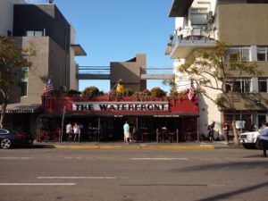
The Waterfront
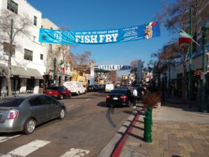
Little Italy and the Our Lady of the Rosary Church Friday Fish Fry
(For the record: I passed on a beverage at The Waterfront, and am damn sorry we’ll miss the fish fry.)
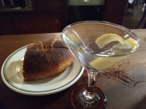
With my arrival in San Francisco, I sought out a martini at Comstock Saloon. Meh, for the bartender ignored dry and twist, after asking, but I love the monkey on the light base.
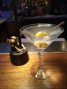
Comstock Saloon Martini
Friday night took me to Tadich Grill. Great, $8.00 martinis. Good food, and I like a place which mentions its staff on its home page, before you hear about the food, the drinks, blah blah. And the caesar salad? Best ever.
Tadich Martini and Boudin Sourdough
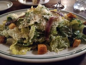
Tadich Caesar Salad
Walking the Trail
Step One
At 5:45 a.m. I walked out of the Galleria Park Hotel to meet my Uber driver. Immediately, two people accosted me, concerned that I would interfere with filming a scene for The Matrix 4. (Fake gunfire and low flying aircraft. If you see the movie, I was there, 30 minutes before it happened.)
Luis found me, blocked streets and all. Off we went, looking for the afore-mentioned Candlestick Point. (Luis had not been there before.)
We got there, directly. Major anxiety hit me, for it’s a desolate place. Candlestick Park exists no more, but for a few signs, reminding fans to drive home safely. No one could have thought, ever, that the location made sense for a baseball team. Here’s one take on the mess. (Trail reviews provide lots of cautionary notes about the starting point.)
In any event, Luis did not pull away as quickly as I might have expected, and I did think he wondered what I was up to. Drug deal? Gonna be left for dead? (I hope the Uber review and tip, offered later, reassured him.)
Map A
And, off I went, one foot in front of the other. The first 3ish miles had me getting away from the Candlestick yuck, wandering though modest neighborhoods and the Visitacion Valley Greenway parks, a series of 6 one block long gardens, traversing a modest elevation rise. (One of the six was locked, and around the block I went.)
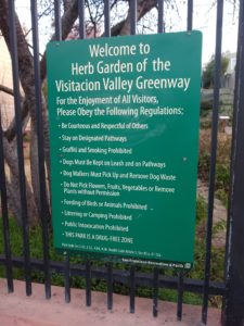
Herb Garden of the Visitacion Valley Greenway
Then, I got to John McClaren Park. A big hill … managed. And a truly lovely park. It brough to mind Cobbs Hill Park, a few blocks from daughter Cate’s first place in Rochester, NY. The McClaren hill was way easier, but both provided great views and just enough of a testing to say Let’s Play Two … Not. (Ernie Banks was a joyful man; not so much the Giants I worshiped in my young years.)
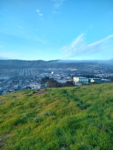
McClaren Park View
Next stop? St. Mary’s Park. I think I got a little lost here. The trail lacks markings, and the app did not seem to have any You Are Here technology. Back and forth with Google Maps helped but I still missed a few places by a block or two. (If you hike the Trail, bring a portable battery charger. Your phone won’t last, with locator on.) Anyway, I progressed.
Map B
The middle leg of the trek had me in Glen Canyon Park for a pretty long while. Discouraged, tired, and ready to wrest this assurance from everyone close to me: No flights of fancy. Ever. Again.
I managed, though, and once I hit asphalt and cement, things got better. I realized, as well, that while the Trail uses some roads – and the roads support cyclists – the wilderness challenged me. Stumbles and, frankly, finding the places. Oh, and there are printed maps A, B, and C maps, while the online app breaks the trip up into more pieces. Confusing!
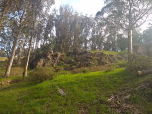
Glen Canyon Park
Out of Glen Canyon Park, I think I missed a spot because of locked fences and Improvements Coming signs. Missing the connection, I missed Golden Gate Heights Park, the Green Hairstreak Corridor, and Grandview Park. But I did find Laguna Honda, and I walked along that “parkway” all the way to where I needed to be finish up Map 2, which included a true highlight: the ponds in the central part of Golden Gate Park. Or course, in addition to water and ducks and such, there were children. And dogs! Can anything be better?
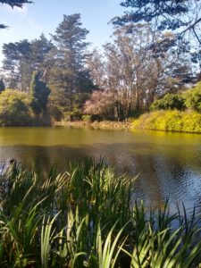
Golden Gate Park Pond
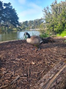
My New Friend
Map C
Out of Golden Gate Park I varied the route. My loss. I walked west on Clement St. to 2725, the Usual Place of Residence of Rochelle Rubin, per my birth certificate. Not a problem but for missing terrific views, reportedly, of the Golden Gate Bridge from Lands End. I should have followed the path and done Clement St. heading back. (OTOH, a cousin lived in Sea Cliff, east of Lands End, and I recall the bridge seeming to be a poster in her living room window.)*
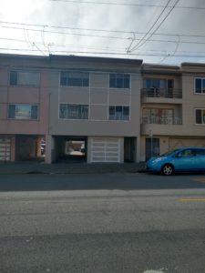
2725 Clement St.
Wrapping Up
So, I got to the end. Lands End aka finis terra. I wandered into the Cliff House and wisely, I think, decided to pass. Uber got me to the Letterman Digital Arts Center at the Presidio. It occupies the ground on which Letterman Army Hospital sat, on September 14, 1957 (and before and after). The place of my birthing.
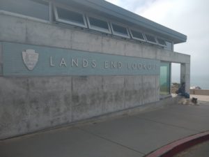
Lands End
Then, almost three miles back to my hotel, on foot. (I did detour slightly to Murphy’s Pub for lots of water, a celebratory cocktail, and French Fries. (Vegan, right? Ergo, healthy.) No pics; sorry!
I’m not especially sentimental. Yes, my mother-in-law did re-stuff a dog I had 60 years ago, but the Timberland Boots from high school fit my feet, and while I’d never use them for hiking, they work well in mud. And I toss lots of stuff.
I am dying, but only in the way that we all are: days pass, and some day I will be gone. Not soon, I hope and expect, and nothing tells me I’m wrong about that expectation. So I don’t think this was a Last Hurrah deal.
I don’t know, therefore, what moved me to want to see the usual place of residence. (Zillow gave me a perfectly good photo, but you got mine.) The hike was surely, in part, a Can I Do This / I Can Do This thing. And I do enjoy the Tadich Grill experience. But I got to see a city in way other than the normal way, for affluent white professionals.
Every time I visit New York, I tell myself I need to go to Queens or the Bronx. It never happens! And, truth be told, the Trail emphasizes wilderness, as against the hoods. That San Francisco has so much preserved property says much, and I’m off my high horse.
Who knows? Too much navel gazing for right now. I need to get out of this room and walk a bit. Sunday will take me to a car, to Napa to visit my aunt, and on Monday the real word returns.
One more thing, about the South to North direction. The second half of the trail gets much flatter, and much prettier.
*FWIW, I don’t like bridges. For Napa, I’m taking BART to the Oakland airport, from where I leave on Monday, so I don’t have to drive over either bridge out of San Francisco. More on that issue some other time.